Offline Map Navigation
- 4.3
- Rating
- 10.00M
- Installs
- Free
- Price

 Analysis by App-foxy
I spend enough time driving in unfamiliar places to know that a navigation app is only as useful as it is when the signal becomes unreliable. Offline Map Navigation, developed by VirtualMaze, is built around that exact situation. It is a free maps and navigation app for Android, with offline mapping, GPS guidance, lane assistance, junction views, and Android Auto support. After using it as a practical travel tool rather than treating it like a simple map viewer, I found that its biggest appeal is straightforward: it can reduce dependence on a mobile data connection while still offering the familiar structure of turn-by-turn driving guidance.
The app is not trying to replace every mapping service for every kind of trip. Its strongest case is for drivers who want maps available before they leave home, commuters who sometimes pass through weak-coverage areas, and travelers who prefer to prepare a route instead of relying entirely on a live connection. It has been available since February 19, 2016, and its position in the navigation category is reflected by an average rating of 4.3 from around 95 thousand ratings. That does not make it perfect, but it does suggest that the offline approach has found a substantial audience.
Offline guidance that makes sense before a journey
The first thing I would do with this app is prepare it while connected to Wi-Fi, before starting a long drive. That small habit matters. Offline navigation is most useful when it has been treated as a planned backup rather than something to set up on the roadside. I would choose the area I expect to visit, make sure the relevant map is available, and then test the route while the phone is still online. This workflow gives me confidence that the phone is not being asked to solve two problems at once: downloading map material and guiding me through unfamiliar roads.
You May Also Like

 Blood Strike: 2.5 Anniversary
Blood Strike’s Loadouts Turn Every Drop Into a Tactical Gamble
A close look at Blood Strike’s custom loadouts: how fast access to signature weapons reshapes its battle royale rhythm, rewards preparation, and narrows the gap between fights.

 Pandora - Music & Podcasts
Pandora’s Music Is Easy to Start, but Harder to Recover
Pandora’s strength is its low-effort path from a seed to a station. Its weak spot is how much confidence it asks you to place in connection, setup, and quiet recovery.

 8 Ball Pool
 Is Built on Rivalries, Rematches, and Routine
A close look at the rivalries, rematches, shared routines, and unanswered safety questions that turn a quick pool match into a persistent mobile community.

 Samsung Music
’s Quiet Strength Is Playing What You Already Own
Its reach comes less from spectacle than from dependable access to a personal library. That simplicity is both the app’s strongest retention engine and its ceiling.

 AccuWeather: Weather Radar
AccuWeather Review: A Quick, Clear Forecast for Everyday Decisions
For everyday plans, the best forecast is the one you can understand quickly. AccuWeather makes rain timing, radar, and local conditions easy to act on, with a few trade-offs.

 Hill Climb Racing
Why Hill Climb Racing Still Turns Crashes Into One More Run
A tiny car, a bumpy hill and one more upgrade: Hill Climb Racing keeps resurfacing because its simple chaos makes every near-miss feel personal.
More From Our News Desk



Once the map is ready, GPS can handle the basic positioning task without requiring the same constant data connection as a fully online navigation service. That is especially helpful on rural roads, in underground sections, during road trips across patchy coverage zones, or when traveling abroad and trying to avoid depending on mobile data. The important distinction is that offline access does not make every part of navigation magically live. A prepared map can show the road network and support guidance, but conditions that change minute by minute are a different matter. I would still check the route before leaving and remain alert for signs, closures, and temporary diversions.
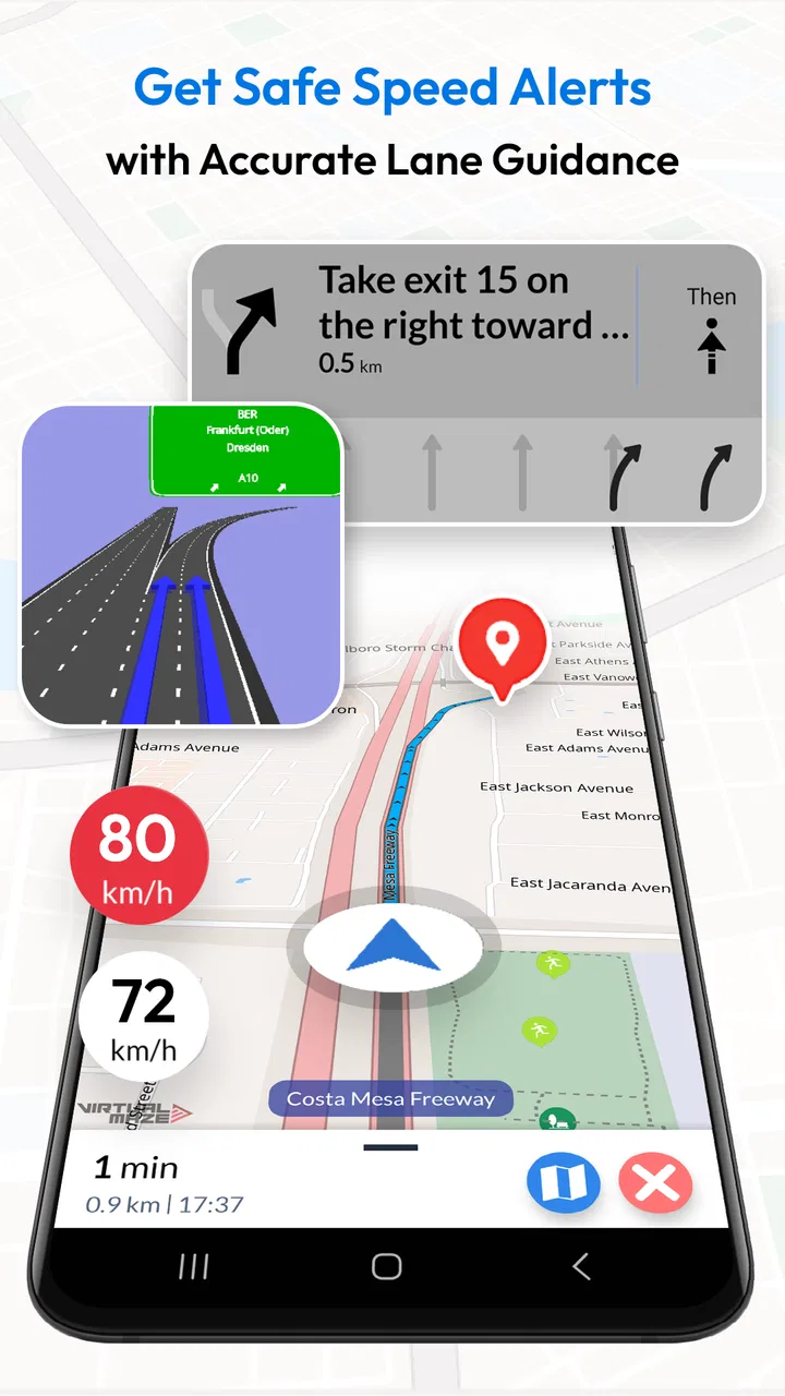
In ordinary use, the interface follows the logic I expect from a driving navigator: select a destination, review the suggested route, and follow visual instructions while moving. The lane assist and junction view are more useful than they may sound. A basic arrow can tell me where to turn, but a lane-oriented indication can help me decide where to position the car before a complicated interchange. The junction view is particularly valuable when several exits appear close together and a quick glance at the screen could otherwise be confusing.
I would not treat those visual aids as a substitute for paying attention. They are support tools, not permission to stare at the display. Their practical value comes from checking them briefly before a maneuver, ideally with the phone mounted where it can be seen without blocking the road. The more complicated the junction, the more useful it is to slow down mentally before reaching it rather than waiting for the last possible instruction.
What the free access actually gives me
The app itself is free to download and use, which makes it easy to test without committing money first. That is important in this category because navigation needs vary so much. Someone may only need offline guidance for one holiday, while another person may use it every week. Free access lets me judge the map experience, route presentation, and comfort of the interface on my own phone before deciding whether it belongs in my regular driving setup.
There are in-app purchases listed from $0.99 to $29.99 per item. I would therefore separate the value of the free app from the value of any optional purchase. The free entry point is the clear advantage: I can explore the core experience without paying upfront. The higher end of the purchase range means I would not buy anything casually, especially when I had not yet identified exactly which extra capability I needed. The sensible approach is to use the free version first, confirm that it covers my routes and driving habits, and only then consider an optional item that solves a specific problem.
This also makes the app easier to recommend to a family member who wants a backup navigator but is not ready to pay for a full premium mapping service. The content rating is Everyone, so it is presented for a broad audience, although the driving context still demands adult judgment and responsible use. A map app can be suitable for general users while the person behind the wheel remains responsible for safe decisions.
VirtualMaze has kept the product focused on a practical navigation job rather than turning it into a social travel platform. That focus is useful when I want to get from one place to another without sorting through extra community content. At the same time, people who enjoy live reports, shared recommendations, or a large ecosystem of connected travel services may find a mainstream online alternative more complete.
Android Auto changes the usefulness of the app
Android Auto support gives the app a more convincing role in a real car. A phone screen is acceptable for occasional use, but integrating navigation with the vehicle display can make route guidance easier to glance at and less distracting than holding the phone in a dashboard cradle. I would still check compatibility with the particular vehicle and phone setup before planning an important journey, because the presence of Android Auto support does not guarantee that every car, cable, or head unit will behave identically.
The best workflow for me would be to prepare the destination on the phone, connect to the car before moving, and confirm that the route is visible on the larger display. That avoids trying to search for a location while already driving. It also gives me a chance to notice whether the selected map area is available and whether the guidance is behaving as expected.
Android Auto is not automatically a reason to choose this app over every competitor. Its value depends on how much I drive and how central the car display is to my routine. If I mostly walk, cycle, or use public transport, this particular strength matters much less. If I regularly drive long distances, however, it makes the app feel more like a proper in-car tool than a backup map sitting on a phone.
Three practical habits that improve the offline experience
My first useful habit would be to prepare a route with a margin around the destination. If I am staying outside a city or visiting several nearby places, downloading only the exact center point may leave me less comfortable when plans change. I would prepare the broader area I expect to explore, while keeping storage and map management in mind. The goal is not to save every possible location in the country; it is to cover the journey and the likely detours.
The second habit is to keep a second form of route context. Before leaving, I would note the main towns, road numbers, or recognizable stops along the way. Offline guidance is convenient, but if I need to make a judgment after a closure or missed turn, knowing the general route helps me recover. This is a subtle advantage of preparation: I am less dependent on the screen for understanding where I am going.
The third is to use the junction and lane information early, not at the last second. I would glance at the upcoming maneuver when there is still time to choose a lane safely. This turns the visual guidance into a planning aid rather than a reaction test. It is especially helpful on multilane roads where the correct exit begins well before the actual junction.
A fourth habit is worth adding for travelers: test the app in a low-connectivity situation before relying on it abroad. I would switch off mobile data or use a known weak-signal location while parked, then search for a nearby destination and inspect the route. That simple check can reveal whether my preparation was adequate without creating stress in a foreign city.
Where it compares well with usual alternatives
The usual alternative is a large online mapping service that combines navigation with live traffic, business information, reviews, traffic incidents, and frequent location updates. Those services are often better when current road conditions are the deciding factor. They can also be more convenient for finding a newly opened business or checking whether a destination is currently busy. Offline Map Navigation answers a different priority: having usable map guidance when connectivity is limited or when I want to reduce reliance on live data.
Compared with a paper map, the app is far more convenient for changing direction and following a route through unfamiliar streets. Compared with a fully online navigator, it may be more reassuring in places where the signal cannot be trusted. The trade-off is that I need to think ahead. A paper map requires interpretation, while an online app can often react to current conditions; this app sits between those approaches by offering digital guidance with an offline preparation requirement.
That middle position is its real identity. It is not merely a static atlas, because GPS guidance, lane assist, junction views, and Android Auto give it an active driving role. It is also not the same kind of live information hub as the most connected alternatives. I would choose it when dependable access to the map matters more than having every current event displayed automatically.
Limitations I noticed in the decision process
The main friction is the responsibility placed on the user before departure. Offline navigation only works smoothly if the relevant map area has been prepared. Forgetting that step can turn a promising backup into an uncertain one. I would not install the app five minutes before leaving for an airport or remote destination and assume the job was finished. Preparation is part of the product experience, not an optional extra.
Map freshness is another practical consideration. Roads change, businesses move, and junction layouts are updated. An offline map can be perfectly useful for a familiar trip and still be less trustworthy around a recently altered road system. When a journey depends on a new development, temporary traffic arrangement, or current congestion, I would cross-check with a live source before setting off.
There is also a difference between route guidance and destination discovery. If I already know where I am going, the app's focused approach makes sense. If I want to browse restaurants, compare user reviews, inspect opening information, or make spontaneous plans based on current local activity, a broader online service may save time. I would not choose this app as my only travel companion for an itinerary built around discovery.
The optional purchase range also deserves a careful approach. Free access lowers the barrier, but a purchase can become poor value if I do not know what problem it addresses. I would read the purchase description inside the app and compare it with my actual needs rather than assuming that the most expensive item is automatically the best experience. Since the app can already be tried without an upfront fee, there is little reason to rush that decision.
Who is most likely to get real value?
I think the strongest match is a driver who frequently travels through areas with inconsistent coverage. That could be someone crossing mountain roads, visiting countryside destinations, or taking long trips through regions where a connection may disappear for stretches. The app is also a sensible backup for people who prefer to prepare maps on Wi-Fi before traveling and want GPS guidance available without making their route dependent on a continuous data connection.
It can also suit a cautious traveler who wants a second navigation option on the phone. For example, I might use a live service for traffic planning at home, then keep this app prepared for the sections of a holiday where the signal is uncertain. That is not redundant if the two tools serve different purposes. One helps me understand current conditions; the other gives me a fallback route reference when connectivity becomes the weak point.
The app is less compelling for someone whose driving is almost entirely urban and whose main concern is real-time congestion. In that case, a service built around live traffic and constantly changing local information may be a better primary choice. I would also skip it as a main navigation tool if I rarely drive and mainly need walking directions, public transport planning, or rich destination search.
Families may appreciate the free starting point, but I would still set it up before handing the phone to a new driver. The driver should not be expected to search, download, and adjust maps during a trip. A passenger can help with preparation, while the person driving can concentrate on the road and use the guidance only as a quick reference.
My buy-or-skip verdict
My verdict is to try it if offline driving guidance is the reason you are looking for a navigation app. The free access makes that decision low risk, and the combination of GPS navigation, lane assistance, junction views, and Android Auto gives it more practical depth than a simple downloaded map. I would prepare the route in advance, test it before a major journey, and keep expectations realistic about live traffic and recently changed roads.
I would not pay for an optional item until I had used the free experience long enough to identify a clear benefit. The listed purchase range runs from $0.99 to $29.99 per item, so the value of paid access depends entirely on what the specific purchase adds for my use. Free access is easy to justify as a backup; paid value needs a more personal reason.
For me, the app earns a place on the phone because it addresses a real weakness of ordinary online navigation: the assumption that a connection will always be there. It is not the best universal map for live city information, spontaneous discovery, or traffic-led route decisions. But for a prepared driver who wants offline maps with proper navigation features, it is a credible and practical choice. With over five million installs, it has clearly reached a wide audience, and my recommendation is simple: install it before the trip, not during the emergency that made you wish you had it.
FAQs for Offline Map Navigation
01What features does Offline Map Navigation offer?
Offline Map Navigation provides turn-by-turn directions, voice guidance, and real-time traffic updates without needing an internet connection. It also includes features like route planning, offline search for places of interest, and customizable map views. This makes it perfect for travelers who want reliable navigation without data usage.
02How does Offline Map Navigation work without internet access?
Offline Map Navigation uses pre-downloaded map data stored on your device. Before you travel, you can download maps for specific regions, ensuring you have access to navigation even in areas with poor or no internet connectivity. This ensures seamless usage without relying on mobile data.
03Is Offline Map Navigation free to use?
Offline Map Navigation typically offers a basic version for free, which includes essential navigation features. However, there might be premium options available for purchase that provide additional features like advanced route options, ad-free experience, and enhanced map data. Check the app store for detailed pricing information.
04Can I update maps in Offline Map Navigation?
Yes, you can update maps in Offline Map Navigation. The app periodically releases new map updates to ensure accuracy. You can download these updates when you have internet access. It's recommended to keep your maps updated for the most accurate navigation experience.
05Does Offline Map Navigation consume a lot of storage space?
Offline Map Navigation requires storage space on your device to save map data. The amount of space depends on the regions you download. While maps can take up significant space, the app allows you to manage downloads efficiently by selecting only the necessary regions, ensuring optimal use of your device’s storage.
Pros
- Works without internet connection.
- Detailed maps with rich landmarks.
- User-friendly interface for ease of use.
- Turn-by-turn voice navigation.
- Regular updates with new maps.
Cons
- Large app size takes up storage.
- Limited real-time traffic updates.
- Some features locked behind paywall.
- Occasional GPS signal loss.
- Interface can be slow on older devices.

Offline Map Navigation
Gallery